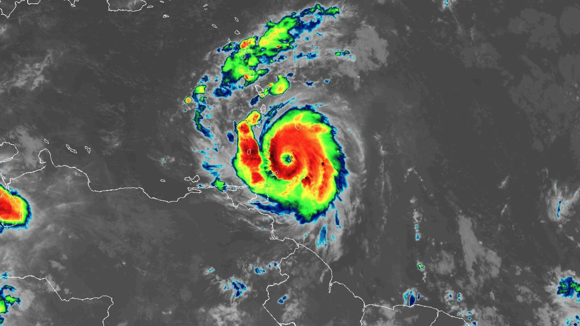
Infrared satellite image of Hurricane Beryl on July 1 as it neared the Windward Islands. Photo: NOAA
Hurricane Beryl, which formed Saturday evening, rapidly intensified into a major Category 4 storm Sunday, and is nearing the Windward Islands Monday morning as a Category 3 major hurricane.
Why it matters: The storm is rewriting hurricane history. Its early formation, rapid intensification and location are all record-breaking.
Threat level: Hurricane Beryl is expected to bring “Potentially catastrophic hurricane-force winds” and “a life-threatening storm surge” to the Windward Islands, with tropical storm force winds beginning Sunday night, the National Hurricane Center stated.
- The Windward Islands include St. Lucia and Martinique. The storm also threatens the southern Leeward Islands, including the Virgin Islands and Antigua.
- The National Hurricane Center singled out St. Vincent and the Grenadines and Grenada for the highest risk of experiencing the worst of the storm.
- Storm surge flooding of six to nine feet above normal tide levels is expected in island areas where the wind is blowing onshore as the storm hits.
- Hurricane warnings are in effect for: Barbados, St. Lucia, St. Vincent and the Grenadines, Grenada and Tobago.
Stunning stat: “Hurricane Beryl took just 42 hours to go from a tropical depression to a Category 3 storm,” according to meteorologist Sam Lillo. “This has been done 6 other times in Atlantic hurricane history. And the EARLIEST date this was achieved before was … September 1,” he posted on X.
State of play: As of 5am ET Monday, Hurricane Beryl was located about 140 miles southeast of St. Vincent, moving west at 20 mph.
- Its maximum sustained winds were 120 mph, making it a major Category 3 storm. It is forecast to regain Category 4 status Monday evening.
- These winds may fluctuate somewhat as the storm builds a new inner core, but the storm is expected to remain a major hurricane through the Windward Islands.
- However, it does not appear to be a clear U.S. threat, though residents of Texas and Louisiana in particular should pay attention to forecasts.
The big picture: Its formation so far east, in what’s known as the “Main Development Region” of the tropical Atlantic, this early in the season broke a record first set in 1933.
- It also became the first major hurricane at such an eastern location so early in the season.
- Hurricane Beryl is now the earliest Category 4 storm to form anywhere in the Atlantic Ocean, beating the old record by more than a week.
- It is also the strongest June Atlantic hurricane on record, and could be the strongest on record to hit the southern Windward islands at any time of year.
- It’s the first Atlantic hurricane in what is expected to be an extremely active season.
How it works: Studies shown that climate change is raising the likelihood that tropical storms and hurricanes will rapidly intensify, compared to several decades ago, and make larger leaps in intensity as well.
- Such an intensity jump this early in the season, and east of the Windwards, is unheard of, however.
Between the lines: This storm is a Cape Verde-type tropical cyclone, since it originated from a group of thunderstorms called a tropical wave that moved off the west coast of Africa.
- Typically, these types of storms don’t form until August or September, when ocean waters warm sufficiently and winds in the atmosphere above this region slacken, to promote the organization of tropical waves to spin up into tropical cyclones.
Yes, but: This season is anything but normal.
The intrigue: The waters of the North Atlantic Ocean Basin are at record to near-record highs, including within the Main Development Region.
- Since tropical storms and hurricanes derive their energy from warm ocean waters, this raises the odds for early season storms in unusual locations, along with an extremely active season overall.
- In the Caribbean, the waters are as warm as they typically would be in early-to-mid September.
Context: The record warm North Atlantic is part of a global spike in ocean temperatures that has gone on for more than a year, and is in large part due to human-caused climate change.
- While 2023 was the planet’s warmest on record, so far, 2024 is running event hotter worldwide.
- In addition, studies show they deliver more rainfall than as a result of warming sea and air temperatures.
What’s next: Computer models are in agreement that the storm will move west-northwest during the next two days.
- It will battle more hostile atmospheric conditions in the Caribbean, and weaken some during midweek.
What we’re watching: The long-range path the storm takes is uncertain, as it could move west into Central America or the Yucatan Peninsula, or try to enter the Gulf of Mexico.
- Most computer models discount the scenario of the storm threading the needle between land areas to enter the bathtub-warm waters of the Gulf of Mexico.

